


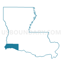
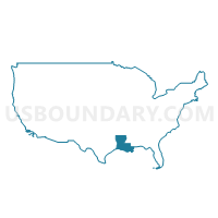
Precinct 1, Cameron Parish, Louisiana
About
Outline

Summary
| Unique Area Identifier | 588390 |
| Name | Precinct 1 |
| County | Cameron Parish |
| State | Louisiana |
| Area (square miles) | 575.77 |
| Land Area (square miles) | 346.34 |
| Water Area (square miles) | 229.43 |
| % of Land Area | 60.15 |
| % of Water Area | 39.85 |
| Latitude of the Internal Point | 29.79805940 |
| Longtitude of the Internal Point | -93.67495330 |
Maps

Graphs
Select a template below for downloading or customizing gragh for Precinct 1, Cameron Parish, Louisiana


Neighbors
Neighoring Voting District (by Name) Neighboring Voting District on the Map
- Voting District 0001, Orange County, TX
- Voting District 0025, Orange County, TX
- Voting District 0032, Jefferson County, TX
- Voting District 0076, Jefferson County, TX
- Voting District 0094, Jefferson County, TX
- Precinct 15, Cameron Parish, LA
- Precinct 2, Cameron Parish, LA
- Precinct 3, Cameron Parish, LA
- Precinct 4, Cameron Parish, LA
- Precinct 760, Calcasieu Parish, LA
Top 10 Neighboring County Subdivision (by Population) Neighboring County Subdivision on the Map
- Port Arthur CCD, Jefferson County, TX (110,068)
- Orange CCD, Orange County, TX (27,482)
- Bridge City-Orangefield CCD, Orange County, TX (14,938)
- District 12, Calcasieu Parish, LA (13,429)
- Sabine Pass CCD, Jefferson County, TX (2,064)
- District 2, Cameron Parish, LA (1,262)
- District 6, Cameron Parish, LA (409)
- District 1, Cameron Parish, LA (288)
Top 10 Neighboring Place (by Population) Neighboring Place on the Map
Top 10 Neighboring Unified School District (by Population) Neighboring Unified School District on the Map
- Calcasieu Parish School District, LA (192,768)
- Port Arthur Independent School District, TX (52,259)
- West Orange-Cove Consolidated Independent School District, TX (17,359)
- Bridge City Independent School District, TX (12,918)
- Cameron Parish School District, LA (6,839)
- Sabine Pass Independent School District, TX (396)
Top 10 Neighboring State Legislative District Lower Chamber (by Population) Neighboring State Legislative District Lower Chamber on the Map
- State House District 21, TX (137,058)
- State House District 22, TX (126,184)
- State House District 33, LA (45,884)
- State House District 47, LA (39,314)
Top 10 Neighboring State Legislative District Upper Chamber (by Population) Neighboring State Legislative District Upper Chamber on the Map
- State Senate District 17, TX (847,887)
- State Senate District 4, TX (790,149)
- State Senate District 25, LA (117,807)
- State Senate District 30, LA (116,727)
Top 10 Neighboring 111th Congressional District (by Population) Neighboring 111th Congressional District on the Map
- Congressional District 8, TX (833,770)
- Congressional District 2, TX (782,375)
- Congressional District 7, LA (676,785)
Top 10 Neighboring Census Tract (by Population) Neighboring Census Tract on the Map
- Census Tract 9701, Cameron Parish, LA (4,883)
- Census Tract 224, Orange County, TX (4,834)
- Census Tract 34, Calcasieu Parish, LA (4,619)
- Census Tract 203, Orange County, TX (2,651)
- Census Tract 116, Jefferson County, TX (2,064)
- Census Tract 9702.01, Cameron Parish, LA (1,956)
- Census Tract 51, Jefferson County, TX (1,043)
- Census Tract 9900, Jefferson County, TX (0)
- Census Tract 9900, Cameron Parish, LA (0)
Top 10 Neighboring 5-Digit ZIP Code Tabulation Area (by Population) Neighboring 5-Digit ZIP Code Tabulation Area on the Map
- 77630, TX (26,796)
- 77640, TX (16,875)
- 77611, TX (8,219)
- 70668, LA (6,424)
- 70645, LA (1,262)
- 70631, LA (962)
- 77655, TX (356)